Winstanley Moated Homesteads

WINSTANLEY MOATED HOMESTEADS
Derek Winstanley
Champaign, Illinois, USA.
August 10, 2022
Winstanley Hall, a fine Elizabethan stone hall, was built in Winstanley Park by Thomas Winstanley and his wife, Elizabeth, around 1560. Prior to that time the Winstanleys occupied a moated wooden homestead a short distance northwest of the hall. This document provides information on this moated homestead and another moated homestead in Blackley Hurst, a detached part of Winstanley in Billinge, now Merseyside.
I start by describing the manor and township of Winstanley and include information on the homesteads and early members of the Winstanley family. I then provide additional information about Winstanley contained in the Domesday Book of 1086. Further information is gleaned from estate plans and Ordnance Survey (OS) maps starting in 1849. LIDAR scans are analyzed to reveal previously unreported information about both moated homesteads. I then provide an interpretation of all the evidence about the moated homesteads.
WINSTANLEY
The name Winstanley is defined by Ekwall in the Concise English Dictionary of English Place Names1 as an Old English name meaning Wynstan’s Leah – a wood or clearing. Old English was the language spoken in England from roughly 500 to 1100. The Anglo-Saxons were a cultural group who inhabited England in the Early Middle Ages. They traced their origins to settlers who came to Britain from mainland Europe in the 5th century. Anglo-Saxon identity arose from interaction between incoming groups from several Germanic tribes, both amongst themselves and with indigenous Britons, such as the Brigantes.
Before the Norman Conquest in 1066, it is reported that Billinge and Winstanley were one manor, and probably formed one of the berewicks of Newton2. In 1212 Roger de Winstanley held the Winstanley manor under the lord of Billinge3. Probably around this time, Billinge and Winstanley were formed as two separate parts of the Barony of Newton-in-Makerfield. Winstanley became an independent manor with its own court. Subsequently, the Anglian settlement of Billinge was subdivided into two parts, Billinge Chapel End and Billinge Higher End.
Edmund Winstanley, the son of Thomas and Elizabeth, sold Winstanley Hall and Estate to James Bankes in 15964, and they remained with the Bankes family until 2000, when the hall was sold to Dobcrest.
Figure 1 shows the outline of the medieval boundaries of Winstanley township including two detached parts of Winstanley in Billinge, one south of Newton Road in Billinge and the other in Birchley. The detached part of Winstanley south of Newton Road was the domain of Blackley Hurst Hall5.
 Fig 1 - 1911 map of the medieval townships in the Parish of Wigan
The gentle eastern slopes of Billinge Hill are incised by a number of small tributary streams of the river Douglas, creating a well-drained and fairly undulating landscape. Winstanley Park sits within this landscape; the maximum altitude of the park being about 330 feet at Camp Hill in the south-west and the minimum about 160 feet at Pony Dick to the east. The line of the Tinker Hole Fault runs from southwest to northeast across the central part of the park with a throw of up to 355 feet to the southeast. To the east of the fault the coal measures are not obscured by drift deposits; whilst to the west of the fault there is superficial cover of glacial boulder clays, which underlies most of the northern half of the park, including the moated area and the Mossey Croft Wood area.
Figure 2 shows a recent satellite photo of Winstanley Park. The old moat is on the northside of the Moat House with gardens to the south. The walled gardens were constructed in the late 18th century7. A dark line crosses from southwest to north east between the Winstanley Hall and moat. The M6 is to the west. Lea Wood is the line of trees to the east of the hall and Pony Dick is on the east side. Winstanley Park occupies almost a third of the whole area of Winstanley Township.
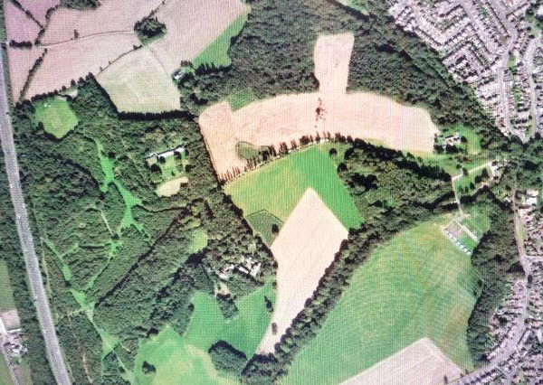 Fig 2 - Satellite photograh of Winstanley Park The moat comprises part of a Scheduled Ancient Monument (SM 22481/01)7, along with a group of fishponds (SM 22481102) located about 600 feet to the northeast in Workshop Wood. The moated site includes a rectangular island measuring about 150 feet by 120 feet and is surrounded on three sides by a waterlogged moat up to 45 feet wide and 3 feet deep to the water level. The moat's southern arm is dry and has been partially infilled. There is an inlet channel at the moat's north-western corner and an outlet channel at the north-eastern corner.
Flanking the waterlogged moat is an outer bank up to 30 feet wide and 3 feet high.
Access to the island is by a causeway on the western arm. Despite some disturbance to the island by tree roots and partial cleaning and infilling of the moat, Winstanley moated survives well. Evidence of the original buildings will exist upon the island5.
A walled garden was constructed to the south of the moat in the late 18th century. The garden is not shown on the estate plan of 17708 (Figure 3) and the earliest evidence for its existence is the estate plan of 1792. The west, north and east sides of the garden had high brick walls, but a ha-ha forms the southern boundary. An example of a ha-ha is shown in Figure 4. A possible precursor for the walled garden may have existed within the moated site, where cartographic evidence has suggested that a garden may have existed within the post-medieval period. Such a scenario would help to explain why the walled garden is located in such close proximity to the medieval moated site.
 Fig 3 - Estate Plan 1708
 Fig 4. -Comparison of a ha-ha (top) and a regular wall (bottom)
Both walls prevent access, but the ha-ha does not block the view.
Figure 5 shows a 1980 photograph of the north side of the moat and a recent photo of the moat taken from within Moat House.
 Fig 5 - Two photographs of Winstanley Park Moat
Figure 6 shows part of the Domesday Map of 1086. Winstanley is marked; Billinge and Wigan are not. The accompanying text states that “Wulfbert held “Wibaldeslei. There are 2 carucates of land. It is worth 64d” 10. Two caractures of land were about 240 acres. Wulfbert was probably tenant in chief over, or lord of the manor, under Roger de Poitou who was given much of the land between the River Mersey and River Ribble by King William after the Conquest of 1066. As Wulfbert is an Old English name, it is likely that a Winstanley settlement existed in Early Medieval times. The name Wulfbert was rarely used after the Conquest and the names of heads of the Winstanley family then included Roger, James, Edmund and Thomas. Joyce Bankes4 reports that the Winstanleys of Winstanley lived in their “Homestead Moat” adjacent to the old Pack Horse Salt Way.
Wood clearance increased during the Bronze Age (2400-750BC) to its probable height in the early Iron Age. About half of England had ceased to be wildwood by 500BC. In 1086 only about 15 percent of England was woodland or wood-pasture12.
Fragments of natural remnants of woodlands occur on quite inaccessible steep slopes. Lea Wood, Mossey Croft Wood and Blundell’s Wood along Smithy Brook eastwards from Pony Dick probably originated as such fragments. although the vegetation undoubtedly has changed over time.
 Fig 6 - Map of the Winstanley area in the 1086 Domesday Book
At this time, I introduce a recent LIDAR map of Winstanley Park. I will describe some prominent features and then examine old plans and maps to garnish as much information as possible about the moat and ancillary features, keeping in mind that construction of the moat and ancillary features predates the earliest map by hundreds of years. Figure 7 shows a LIDAR map of Winstanley Park and Figure 8 is a LIDAR map of the central area.
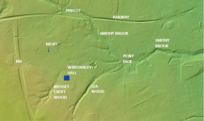 Fig 7 - LIDAR Map of Winstanley:1 (ArcGIS)
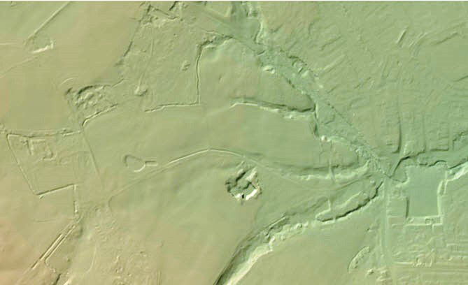 Fig 8 - LIDAR Map of Winstanley:2 (ArcGIS)
Key features of the LIDAR maps are as follows:
Several incised streams or headwaters: Smithy Brook, which flows east from Pony Dick into the River Douglas in Wigan, Lea Wood and in Mossey Croft Wood.
Pronounced ditches for the west, north and east arms of the moat and on the east part of the south side. There is no ditch along the west part of the south side of the moat. The land between these four sides, where the wooden manor house would have been located, appears elevated.
Two well-defined parallel and straight cuts or ditches from the northwest corner of Mossey Croft Wood leading to the southeast of the homestead area.
Two water bodies in Mossey Croft Wood with a cut or ditch from the northwest corner of the northern water body into the eastern cut or ditch.
A well-defined straight cut or ditch from the southeast to the southwest corner of the homestead area with a less pronounced cut or ditch from the southwest to northwest of the homestead.
A cut or ditch from the northwest corner of the homestead into the northwest corner of the moat itself.
A well-defined cut or ditch from the northeast corner of the moat eastward to the south side of Woodshop Wood and ponds, with a less pronounced cut or ditch continuing to the east and then north to a stream that flows into Smithy Brook.
A pronounced cut or ditch from the pond to the east of the moat that continues into an incised stream flowing into Smithy Brook at Pony Dick.
A stone quarry to the south of this stream (provided sandstone to build the hall).
Fishponds and a depression northeast of the moat (probably formed by extracting clay to make the bricks for the walled garden).
A depression northwest of the moat (Clarke’s No. 7 pit c.1795).
Winstanley Hall shows little imprint.
I now look at early plans and maps to investigate if the above LIDAR features can be further interpreted.
The 1770 map (Figure 3) shows two main roads or pathways to Winstanley Hall: one from the old road from Windy Arbour to Orrell and Upholland, before Winstanley Road and the M6 were built, running along the west side of Mossey Croft Wood; the other from Pony Dick along the side of Lea Wood. A building or buildings are shown where the Mossey Croft Road joins old Winstanley Road. Three water bodies are shown in Mossey Croft Wood. A three-sided moat is shown with a small pond within the east side of the moated mound. Salterly Fields are evident to the northeast of the moat. In the 16th century the brook dividing Winstanley from Orrell (Smithy Brook) was known as Salters Brook.
The 1792 and 1820 estate plans7 show a four-sided moat and a garden to the south. The 1838 tithe plan shows a four-sided moat with a small entrance through the south side. Figure 913 shows the map of Winstanley Park that highlights the outcrop of the Orrell 5ft and 4ft coal seams. The post-1770 road from Pony Dick to the hall joins the road from the old Winstanley Road past the north side of Mossey Croft Wood and this continues northward past the southeast corner of the moat gardens to join the more northerly road from the old Winstanley Road that continues eastward to Pemberton across the Pingot.
 Fig 9 - Map of northern part of Winstanley Park c.1820
The 1849 OS map (Figure 10) shows the following points of interest:
A small lodge at the junction of a line from Mossey Croft Wood to the old Winstanley Road. (In 1985 Donald Anderson said that “This was originally the entrance into the Park off the ancient highway before Winstanley Road was constructed“.
Complex pathways in Mossey Croft Wood, a conservatory, two water bodies and three fountains around Winstanley Hall.
Roads to Winstanley Hall from the Wigan Lodge south of Pony Dick, Billinge Lodge off to the south of the map and the lodge in 1 above converging to the east of Camp Hill and then splitting to the front and rear of the hall, with a road from the hall to Mossey Croft Wood.
A three-sided moat with a separate section of moat on the south side.
Buildings and a garden to the south of the moat.
A pathway from Mossey Croft Wood to the southeastern corner of the moated homestead and extending along the eastern side of the walled garden.
The moat is not located close to any other significant surface waters, such as Smithy Brook or the stream through Lea Wood.
The road to Winstanley Hall from Pony Dick to the hall is no longer shown. A new road to the hall from Pony Dick to the north of Delph Plantation is shown.
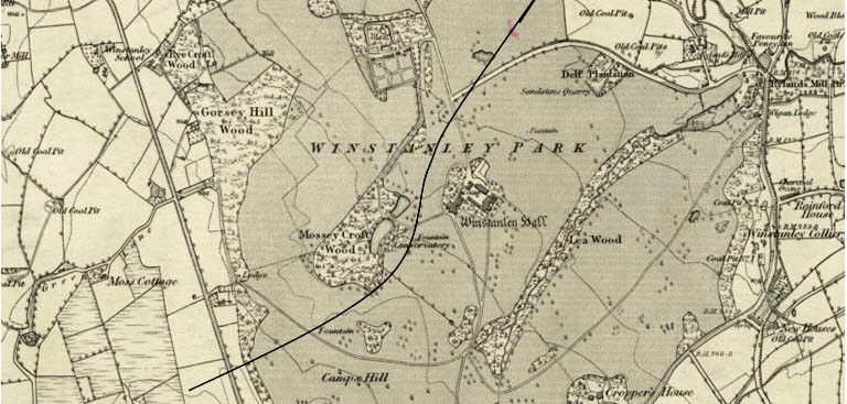 Fig 10 - 1849 OS Map Winstanley Park (Tinker Hole faultline added) On the 1894 OS map (not shown) sluices are indicated at the northern end of both water bodies in Mossey Croft Wood.
The 1929 OS map (Figure 11) more clearly shows the contours of the land. The elevation generally decreases from about 350 feet west of Mossey Croft Wood to about 250 feet at the moat. The moat is located at the foot of the slope where the land flattens out. The elevation of the north water body in Mossey Croft Wood is lower than the south water body. The 275 feet contour northwest of the north water body shows a W configuration, indicating two cuts either side of a raised higher platform. The 300 ft contour o the west of Mossey Croft Wood does not show such configuration. Along the southern side of the gardens and the northwest corner of the moat the contours indicate cuts. A stream flows into the northwest corner of the moat and a stream at slightly lower elevation flows eastward out of the northeastern corner of the moat.
The moat is not located close to any other significant surface flow of water, such as Smithy Brook or the stream through Lea Wood.
 Fig 11 - 1929 OS Map of Winstanley Park
Figure 12 shows the moat around Blackley Hurst Hall, south of Newton Road in Blackley Hurst, a detached part of Winstanley in Billinge built prior to 1533.

MY INTERPRETATION
More than a thousand years ago the Winstanley family cleared woodland and built a moated homestead northwest of today’s Winstanley Hall.
A wooden building in the moated site served as a prestigious home and manor house.
The wooden manor house could have been rebuilt over hundreds of years before being abandoned, probably in the 15th century.
The location of the homestead met the requirements for fairly flat land, a sheltered position, water supply, drainage, fertile soil, protection and security, access to wood, clay and possibly coal and connection to a road.
The homestead was built by the side of an old saltway connecting the old Winstanley Road to Lamberhead Green through Salterly Fields and across Salters Brook in the Pingot.
It is not possible to determine if the saltway existed before the homestead was built, or whether the saltway was built at the same time as the homestead.
The saltway provided the main entrance to the homestead.
To the northwest of Mossey Croft Wood the saltway was on a raised bed flanked on both sides by ditches.
The ponds in Mossey Croft Wood, either natural or engineered by the Winstanleys, were fed by small streams and perhaps by a spring(s). Water from the higher southern pond probably flowed into the lower pond. Water from the ponds was channeled northwest to flow into one or both ditches either side of the saltway.
Water flowed along these ditches to the southeast corner of the homestead site, south of the moat. The saltway continued to the north along the east side of the homestead.
A ditch was built along the south and west sides of the homestead to the northwest corner of the moat to channel water into the moat. The moat was kept full of water, but to maintain clear water and prevent flooding of the manor house a drainage outlet was made from the northeast corner of the moat to flow northeast along the south side of Workshop Wood and possibly further east and then to the north to discharge into a stream that flows into Smithy Brook in the Summersales.
Abundant clay was dug to create channels for water flow. Clay was used to create embankments, raised pathways/roads, the mound within the moat and to line the moat itself. The fishponds within Workshop Wood were probably created in the late 18th century as a result of mining clay to make bricks for the high wall around the walled garden.
The pond to the east of the moat (locally called the fishpond) was probably of natural origin or associated with construction of the moated homestead. Post-1770 a stream was enlarged or constructed from the pond to provide an additional source of water for the mill at Pony Dick.
The fact that the ditch to the south of the moat was considerable distance from the moat, and the area between the moat and the ditch was post-1770 made into a garden, lead me to speculate that this area was probably intensely farmed when the manor home was occupied.
Blackley Hurst Hall was probably built in the 15th century after abandonment of the old wooden moated house in Winstanley Park. In the 15th century the most senior members of the Winstanley family moved to Wales where they were successful in the woolen industry before returning to Winstanley to build Winstanley Hall in Winstanley Park c.1560. Other senior members of the family lived in Blackley Hurst Hall16.
NOTES
Lidar stands for Light Detection and Ranging and is a remote sensing method that uses light in the form of a pulsed laser to measure ranges (variable distances) to the Earth. These light pulses—combined with other data recorded by the airborne system — generate precise, three-dimensional information about the shape of the Earth and its surface characteristics.
A lidar instrument principally consists of a laser, a scanner, and a specialized GPS receiver. Airplanes and helicopters are the most commonly used platforms for acquiring lidar data over broad areas. Lidar can penetrate through buildings and vegetation to reveal the underlying surface of the earth including ditches, embankments and streams.
Lidar maps are available at arc.gis.com.
